Iceland is, in a meaningful sense, almost entirely a natural park. Its lava fields, geothermal valleys, glacial rivers, and black sand coastlines are not ornamental features. They are the landscape, and the country’s entire relationship with its terrain reflects this. The national parks of Iceland are not set apart from this as specially curated exceptions; they are simply the areas where the country’s most significant geological, ecological, and historical assets have been given the formal protection they deserve.
There are three national parks of Iceland: Þingvellir, Vatnajökull, and Snæfellsjökull. Each covers a radically different kind of landscape. Each carries a UNESCO designation or the ongoing pursuit of one. Each offers a geological, historical, ecological, and simply visual depth of experience that makes it worth not merely ticking off a list but spending genuine time in. This guide covers all three in the detail they merit.
Key Takeaways
- Iceland has three national parks: Þingvellir, Vatnajökull, and Snæfellsjökull. Iceland once had five; Jökulsárgljúfur and Skaftafell were merged into Vatnajökull in 2008.
- Vatnajökull is the largest national park in Iceland and one of the largest in Europe, covering over 14% of the country’s entire land area.
- Both Þingvellir and Vatnajökull are UNESCO World Heritage Sites – Þingvellir since 2004, Vatnajökull since 2019.
- All three national parks of Iceland are free to enter, though parking fees and activity fees apply at specific sites within them.
- The national parks are open year-round, with different experiences available in summer (hiking, midnight sun, wildflowers) and winter (ice caves, Northern Lights, snow landscapes).
Þingvellir National Park
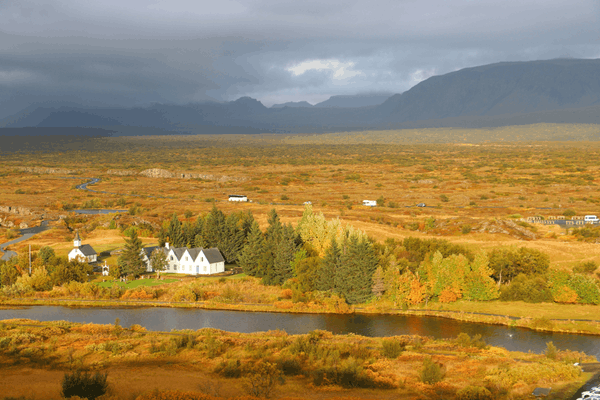
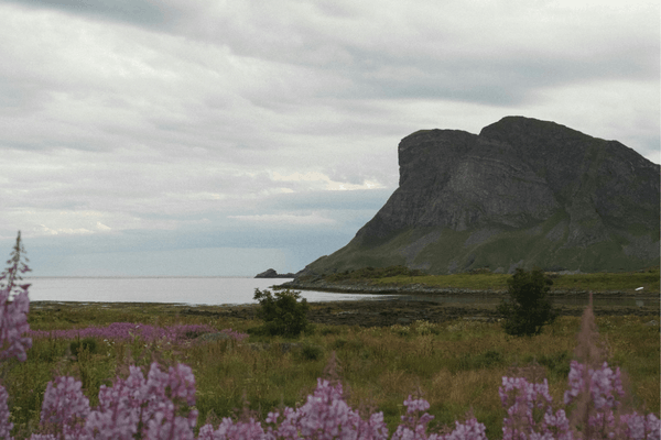
Þingvellir is Iceland’s oldest and most culturally charged national park. It’s the only place on earth where a major tectonic boundary is not only visible at the surface but carries the additional weight of being where a nation was born. Iceland’s first national park, designated in 1928, was awarded UNESCO World Heritage status in 2004, a recognition resting on its extraordinary dual significance: as the site of the world’s oldest democratic parliament, and as one of the most geologically dramatic landscapes in Europe.
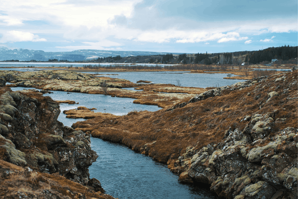
The park sits on the Mid-Atlantic Ridge, directly above the boundary where the North American and Eurasian tectonic plates are slowly pulling apart at a rate of approximately two centimetres per year. The landscape that results from this is unlike anything else on the surface of the earth: wide, flat-floored rift valleys bounded by sheer cliffs of exposed basalt, the ground cracked and fissured in patterns that speak to forces operating on geological rather than human timescales.
The most dramatic Almannagjá gorge runs along the edge of the North American plate for several kilometres, and the trail along its base is one of the most atmospheric walks in Iceland.
Credit: Jörg Hamel
The Althing and Iceland’s Political History
At Þingvellir in 930 AD, Iceland’s early settlers established the Althing, which was the world’s first democratic parliament, a legislative and judicial assembly that gathered annually for two weeks each summer. More than five thousand people would converge from across the island, camping in temporary turf booths around the base of the Lögberg, or Law Rock, from which the Lawspeaker would recite the laws of the land to all assembled.
The Althing continued to meet at Þingvellir until the late 18th century, when it was moved to Reykjavík. It is at Þingvellir, too, that Iceland proclaimed its independence as a republic on 17 June 1944. It was a moment of particular weight, occurring as it did in the middle of the Second World War and on a site that had held national significance for over a thousand years.
The ruins of the ancient stone booths are still visible in the park today. Visitors walking among them are walking through a landscape that has been continuously meaningful for longer than almost any comparable site in northern Europe.
Silfra
Among the most celebrated experiences in any of the national parks of Iceland is snorkelling or diving in the Silfra fissure. It’s a submerged crack in the tectonic boundary at Þingvellir that offers the only place on earth where it is possible to swim directly between two continental plates. The fissure was shaped to its current form by earthquakes in 1789 and is fed by glacial meltwater from Langjökull, Iceland’s second largest glacier, which filters through porous underground lava for between 30 and 100 years before reaching the spring. The result is water of extraordinary purity, with visibility exceeding 100 metres. That’s among the highest of any freshwater dive site in the world.
The water temperature is a consistent 2–4°C year-round, which makes dry suits essential. PADI included Silfra in its 2024 list of the world’s best dive sites. The experience of floating through the fissure, just watching the volcanic rock and the vivid green algae known as “troll hair” passing below, is, by all accounts, one of those encounters with natural phenomena that exceeds its own reputation.
Credit: Nadine Bliedung
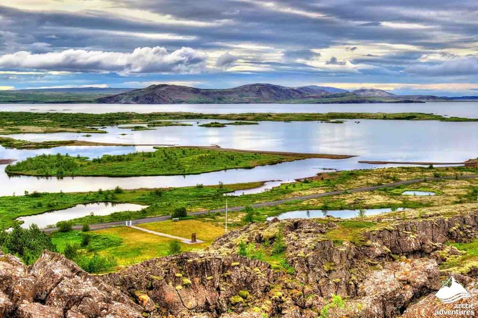
Lake Þingvallavatn
The southern edge of Þingvellir is defined by Þingvallavatn. It’s Iceland’s largest natural lake, covering 84 square kilometres. Its cold, clear waters host an ecosystem of considerable scientific interest, including four distinct subspecies of Arctic char found nowhere else on earth, each adapted to the specific ecological niche it occupies within the lake. Nearly a hundred species of birds have been recorded around its shores in the course of a year, with the lake’s wetlands providing habitat for breeding harlequin ducks, great northern divers, and many others.
The Öxará river threads through the park before emptying into the lake, forming the small but striking Öxarárfoss waterfall as it passes through the Almannagjá gorge. It’s a natural feature whose historical associations with the Althing give even a modest waterfall a weight beyond its physical scale.
Credit: Arctic Adventures
When to Visit Þingvellir
Þingvellir is accessible and rewarding year-round. In summer, the long days and lush green landscapes make it ideal for hiking and photography; in winter, snow covers the lava fields and the Northern Lights can be extraordinary above the dark, flat terrain. The park forms one corner of Iceland’s Golden Circle route alongside Gullfoss waterfall and the Geysir geothermal area, making it a natural centrepiece of any southern Iceland itinerary. It lies approximately 45 minutes from Reykjavík by car.
Vatnajökull National Park
Vatnajökull is the largest of the national parks of Iceland and one of the largest national parks in Europe, covering over 14,141 square kilometres which is more than 14% of Iceland’s entire land area. Named after the Vatnajökull glacier, the largest ice cap in Europe by volume, the park encompasses a landscape of almost impossible variety: glaciers and ice caves, active volcanoes and geothermal areas, some of the country’s most powerful waterfalls, vast lava fields, canyon systems carved by glacial floods, and a coastline where icebergs calve from the glacier’s edge into a lagoon of extraordinary beauty.
The park was established in 2008, incorporating the previously separate protected areas of Skaftafell in the south and Jökulsárgljúfur in the north. In 2019, Vatnajökull received UNESCO World Heritage designation on the basis of its outstanding geological significance. Specifically, what earned this, was the continuous interaction between fire and ice that has shaped its landscape for millennia and continues to do so today.
Credit: Freysteinn G. Jonsson
The Vatnajökull Glacier
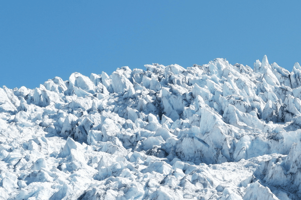
The glacier itself is the park’s dominant presence: a vast ice cap covering approximately 8% of Iceland’s entire landmass, with an average thickness of 400–600 metres and a maximum depth exceeding 950 metres. It is more than 2,000 years old and contains within it – beneath hundreds of metres of ice – ten central volcanoes, including Grímsvötn and Bárðarbunga, two of Iceland’s most active volcanic systems.
The interaction between the ice above and the volcanic heat below produces some of the park’s most dramatic phenomena like: subglacial eruptions that melt ice from below, catastrophic glacial floods (jökulhlaups) that have repeatedly reshaped the lowland landscape south of the glacier, are accessible to visitors each winter or the extraordinary blue ice caves that form within the glacier’s outlet glaciers as meltwater channels hollow out caverns of translucent, compressed ice.
Ice cave tours operate from approximately November through March, when the ice is structurally stable enough to enter safely. The caves are among the most visited attractions in all of Iceland, and for good reason: the quality of light inside them, the deep blue of compressed glacial ice filtering the winter light, is unlike anything achievable above the surface.
Credit: Atli Stefán Yngvason
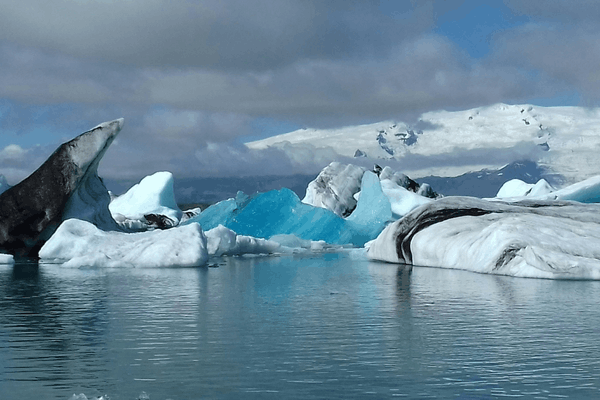
Jökulsárlón Glacier Lagoon
At the southeastern edge of the park, where the Breiðamerkurjökull outlet glacier meets the sea, the Jökulsárlón glacier lagoon has formed over decades of glacial retreat. Icebergs calve continuously from the glacier’s face and drift slowly through the lagoon before being carried out to sea. It’s a journey that deposits them, often, on the black sand beach immediately to the east of the lagoon’s outlet, where they rest photogenically against volcanic sand in a natural composition known as Diamond Beach.
The lagoon hosts a resident colony of seals, who haul out on the floating icebergs and can be observed at close range from the lagoon’s banks. Boat tours of the lagoon operate in summer, allowing visitors to navigate among the ice. In winter, the combination of icebergs, the possibility of Northern Lights, and the surreal blue tones of the glacial ice makes Jökulsárlón one of the most photogenic locations in Iceland.
Credit: Russell Moore
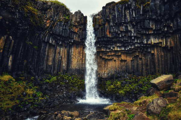
Skaftafell and the Svartifoss Waterfall
In the park’s southeastern section, the Skaftafell area offers the most accessible and varied hiking in Vatnajökull. The area was formerly a separate national park before being incorporated into Vatnajökull in 2008, and it retains a visitor centre, campsite, and well-maintained trail network that makes it an ideal base for exploring the southern park.
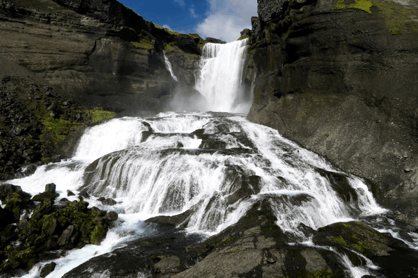
The most celebrated walk from Skaftafell leads to Svartifoss (the Black Waterfall), a 20-metre cascade framed by a natural amphitheatre of dark hexagonal basalt columns whose geometric precision gives the setting an almost architectural quality. These basalt formations inspired the design of Hallgrímskirkja church in Reykjavík, and the visual connection between the natural form and its architectural echo is one of Iceland’s most compelling cultural details.
Credit: Jean Vella
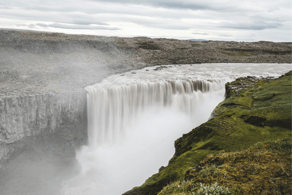
Jökulsárgljúfur and Dettifoss
In the park’s northern reaches, the Jökulsárgljúfur canyon system protects some of Iceland’s most dramatic northern landscapes, including Dettifoss (Europe’s most powerful waterfall by volume), and the horseshoe-shaped canyon of Ásbyrgi, carved by a catastrophic glacial flood in geological prehistory and now covered in birch woodland that feels entirely unexpected in the context of the surrounding highlands.
Dettifoss drops 44 metres over a width of 100 metres, with an average water flow of 193 cubic metres per second fed by the Jökulsá á Fjöllum river, which originates at Vatnajökull glacier. The force of the water is perceptible in the ground beneath your feet as you approach, and the volume of spray generates a permanent cloud above the gorge. Ridley Scott chose Dettifoss as the opening location for the film Prometheus, a choice that speaks clearly to the waterfall’s capacity to suggest something elemental and overwhelming.
Credit: Misha Martin
When to Visit Vatnajökull
The park is accessible year-round, though the experience changes dramatically by season. In summer, hiking trails open, the Skaftafell area comes alive, and the glacier lagoon operates boat tours. In winter, ice cave tours begin, the Northern Lights are visible from the park’s dark camping areas, and the combination of snow, ice, and long nights gives the landscape a stillness and grandeur that summer cannot replicate. The Ring Road passes through the park’s southern section, making several key attractions accessible without a 4WD vehicle; the highland interior requires a 4WD vehicle and is open only in summer.
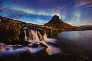
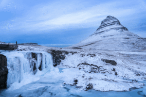
Snæfellsjökull National Park
Snæfellsjökull is the smallest and, in some ways, the most intimate of the national parks of Iceland — a park whose variety and character are disproportionate to its 170 square kilometres. Located at the western tip of the Snæfellsnes Peninsula, it is the only one of Iceland’s three national parks to incorporate both terrestrial and marine environments, and it offers a kind of compressed summary of Icelandic landscape that makes it feel, as many visitors have noted, like the entire country scaled down into a single day’s drive.
At the park’s heart is the Snæfellsjökull glacier and stratovolcano. It’s a glacier-capped peak rising to 1,446 metres above sea level, visible on clear days from Reykjavík 120 kilometres to the southeast. The volcano is approximately 700,000 years old and last erupted around 1,800 years ago; today it is dormant, its summit covered by a glacier that has been receding significantly due to climate change. The icecap area has shrunk from 16 square kilometres in 1946 to approximately 10–11 square kilometres, and in August 2012 the summit was ice-free for the first time in recorded history.
Credit: Wai Lok Chan
Jules Verne and the Journey to the Centre of the Earth
Snæfellsjökull carries a literary significance unmatched by any of the other national parks of Iceland. In Jules Verne’s 1864 novel Journey to the Centre of the Earth, the volcano serves as the fictional entrance to a subterranean world. It’s the starting point of the protagonists’ extraordinary descent. The Vatnshellir lava tube, on the volcano’s slopes, is the park feature most directly associated with this tradition: a 200-metre cave descending up to 35 metres into the earth, its walls showing the successive flow stages of the ancient lava eruption that created it, accessible on guided tours with helmets and torches.
The literary connection gives Snæfellsjökull a cultural dimension quite different from the other national parks, and the park’s mysterious and slightly otherworldly atmosphere makes the association feel entirely appropriate. Halldór Laxness, Iceland’s Nobel laureate, also used the glacier as a central presence in his 1968 novel Under the Glacier, and the park’s place in Icelandic literary culture is as firmly established as its place in geological or natural history.
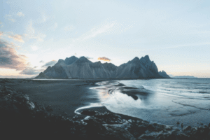
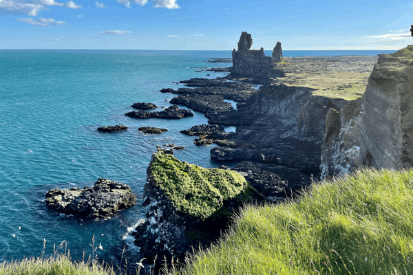
Coastal Landscapes and the Búðahraun Lava Field
Snæfellsjökull National Park’s southern coast is defined by drama: black lava cliffs, sea stacks, rock arches, and beaches of black volcanic sand that meet the North Atlantic with a ferocity entirely different in character from the softer beaches further south along the Ring Road. The villages of Hellnar and Arnarstapi, strung along the coast within the park’s boundaries, are among the most picturesque in western Iceland, connected by a coastal walking trail that passes above some of the park’s most striking cliff formations.
The Búðahraun lava field, which encircles the base of the Snæfellsjökull glacier, contains more than a hundred species of Icelandic flora. The black lava is unexpectedly rich and includes ferns, mosses, and flowering plants that have colonised the porous rock over centuries. The combination of the dark lava, the snow-capped volcano rising above it, and the Atlantic beyond makes this one of Iceland’s most compositionally striking landscapes.
On the northern coast, Skarðsvík offers one of the few golden sand beaches in Iceland. It’s a beautiful geological anomaly in a country where beaches are almost universally black. It’s sheltered by headlands and backed by grassy dunes that feel entirely anomalous and entirely amazing.
Credit: Kirill Prikhodko
Wildlife on the Snæfellsnes Coast
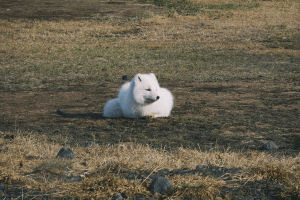
The park’s coastal position makes it one of the best places in Iceland for marine wildlife observation. Iceland’s only native land mammals – Arctic foxes – are regularly seen within the park boundaries. Seabirds nest in the cliffs throughout the summer, and the waters around the peninsula offer some of the most reliable whale-watching conditions in Iceland, with humpback, minke, and occasionally blue whales passing through the offshore waters.
Credit: Jonatan Pie
When to Visit Snæfellsjökull
Summer offers the clearest conditions for seeing the glacier and volcano from a distance, and for hiking the coastal trails in full bloom. The Vatnshellir lava tube is open year-round on guided tours. The park is accessible by car from Reykjavík in approximately two hours via the Hvalfjörður tunnel, making it feasible as a day trip though far more rewarding as an overnight stay that allows time for the coastal walks and the quieter early morning light on the glacier.
Practical Notes for Visiting the National Parks of Iceland
All three national parks are free to enter, though parking fees apply at most popular car parks within each park. The Silfra fissure requires a tour or prior permit from Þingvellir National Park. Ice cave tours in Vatnajökull must be booked in advance and operate only in winter. Vatnshellir cave in Snæfellsjökull is accessible only on guided tours.
Seasonal access varies significantly. Highland areas of Vatnajökull are accessible only in summer and require 4WD vehicles. The ice caves of Vatnajökull operate only between approximately November and March. Vatnajökull’s northern section around Dettifoss may require 4WD access depending on conditions and season. Þingvellir and the accessible areas of Snæfellsjökull are reachable by standard vehicle year-round, though weather conditions demand appropriate tyres and careful driving.
Always check conditions before departing. Weather in Iceland can change rapidly, and conditions in the national parks can become challenging with little to no warning. Safetravel Iceland and road.is provide current conditions and road closure information. The Icelandic Met Office (vedur.is) gives detailed forecasts for specific park areas.
Camping is available within the parks. Þingvellir has a designated campsite open in summer, popular with both visitors and Icelanders. The Skaftafell area within Vatnajökull has a full-service campsite open from May through September. Camping in Vatnajökull away from designated areas is possible with a permit. Snæfellsjökull has campsites in and around the park’s coastal villages. In all three parks, camping outside designated areas requires care and adherence to leave-no-trace principles.
Stay on marked paths. The ecosystems within Iceland’s national parks are often fragile, and the volcanic rock formations, mosses, and other ground cover can take decades to recover from damage.
The moss carpets of Iceland, which give the lava fields their distinctive vivid green, are particularly vulnerable: a single footstep off-trail can leave a visible mark for years. Wandering off-trail near cliffs, glaciers, or volcanic features also carries genuine safety risks that the relatively accessible and visitor-friendly character of the parks can obscure.
Wildlife interactions require distance and restraint. The Arctic foxes, seabirds, seals, and reindeer that inhabit the national parks of Iceland are wild animals in genuine wilderness. Approaching nesting seabirds, seal colonies, or glacial edges more closely than the guidance of park staff suggests is both harmful to the animals and potentially dangerous to visitors. The national parks’ visitor centres at Þingvellir, Skaftafell, and at Snæfellsjökull’s main access points provide current guidance on wildlife activity and sensitive areas.
Photography and drone use. All three national parks offer photographic opportunities of extraordinary quality, but drone use is regulated. In Vatnajökull, regional restrictions apply in specific areas, and blanket drone bans are in force in certain zones for wildlife protection. Drone operators should check the specific regulations with each park before flying. In Þingvellir, the protected status of the UNESCO site means any commercial photography or filming requires prior permission.
Conclusion
The three national parks of Iceland are not an inventory of Iceland’s finest landscapes so much as a set of lenses through which to understand what makes this country so distinctly, so consistently extraordinary. Þingvellir holds a nation’s history within a geological boundary that is itself among the most significant on earth. Vatnajökull showcases why Iceland’s the place among the planet’s most geologically remarkable places. Snæfellsjökull compresses the variety and mystery of the entire island into a single peninsula, capped by a glacier that has been inspiring writers and travellers for well over a century.
These are not parks in the sense of managed green spaces; they are places where the planet’s interior forces are visible and active and occasionally audible, where the history of a civilisation is embedded in the rock and the fissures of the ground, where the silence of an Arctic winter morning on a glacier is a complete experience in itself. To spend serious time in the national parks of Iceland and to walk the Almannagjá gorge in winter light, to watch icebergs drift across the Jökulsárlón lagoon at dawn, to stand below Snæfellsjökull’s snow-covered cone on a clear September morning, is to understand, in the most direct possible way, why this island continues to matter so profoundly to everyone who encounters it.
To experience Iceland’s national parks and the extraordinary landscapes beyond them as part of a deeper, more considered journey through the country, explore our custom Icelandic tours, designed to take you further into the places that deserve it most.
FAQ
How many national parks are in Iceland?
Iceland has three official national parks: Þingvellir National Park, Vatnajökull National Park, and Snæfellsjökull National Park. Together they cover glaciers, lava fields, waterfalls, and historic sites.
Does Iceland have any national parks?
Yes, Iceland has three national parks that protect its unique volcanic and glacial landscapes. These parks showcase Iceland’s natural beauty, from tectonic rift valleys to Europe’s largest glacier.
What is the best National Park in Iceland?
Many consider Vatnajökull National Park the best due to its massive glacier, ice caves, volcanoes, and waterfalls. However, Þingvellir National Park is also highly popular for its historical and geological significance.
What do you eat for breakfast in Iceland?
A typical Icelandic breakfast includes skyr (a thick yogurt), oats, rye bread, boiled eggs, fish spreads, and coffee. In Iceland, breakfasts are simple, nutritious, and often high in protein to suit the cold climate and active lifestyle.