Iceland does not hide what it is. The evidence is in the black lava fields that stretch for miles on the Reykjanes Peninsula, in the steam rising from the ground at every geothermal area, and in the fact that the hot water running from your tap in Reykjavik was heated underground by the same forces that have been reshaping this island for millions of years. Iceland is one of the most volcanically active countries on earth, and the volcanoes that define its character are not merely geological footnotes. They are the essential story of the place.
There are approximately 130 volcanoes in Iceland, of which around 32 active volcanic systems remain capable of eruption. Over the past 500 years, Iceland’s volcanoes have produced roughly a third of the total global lava output. The island sits astride the Mid-Atlantic Ridge (the tectonic boundary where the North American and Eurasian plates pull apart), and simultaneously above a deep mantle hotspot that supercharges this already extraordinary level of activity. Iceland is, in geological terms, a place where the earth is still very much being made.
This guide covers the most significant and most celebrated volcanoes in Iceland: their geological character, their historical importance, their relationship to the landscape and culture that surrounds them, and what visitors can expect to find when they encounter them.
Key Takeaways
- Iceland has approximately 130 volcanoes, with around 32 active volcanic systems spread across the island – the Westfjords being the only region without active geology.
- The island sits on both the Mid-Atlantic Ridge and a deep mantle hotspot, creating one of the highest concentrations of volcanic activity on earth.
- Volcanoes in Iceland span every major type: stratovolcanoes, shield volcanoes, fissure systems, and subglacial volcanoes whose eruptions through ice create catastrophic glacial floods known as jökulhlaups.
- The Reykjanes Peninsula has been in a new volcanic era since 2021, with twelve eruptions recorded through 2025 after 800 years of dormancy.
- Iceland’s volcanic eruptions have shaped European history – the Laki eruption of 1783 affected climate patterns across the Northern Hemisphere, and the Eyjafjallajökull eruption of 2010 grounded over 100,000 flights across Europe.
- Most volcanoes in Iceland can be observed safely and are accessible for guided tours and hiking experiences.
Why Iceland Has So Many Volcanoes
Understanding the volcanoes in Iceland requires understanding the island’s extraordinary geological position. Iceland straddles the Mid-Atlantic Ridge, which is the divergent boundary where the Eurasian and North American tectonic plates are slowly pulling apart at a rate of roughly two centimetres per year. As the plates separate, magma from the mantle rises to fill the gap, creating new crust and occasionally erupting at the surface.
What makes Iceland unique, even among countries that sit on the Ridge, is the presence of a deep mantle plume (a hotspot) directly beneath the island. This upwelling of abnormally hot material from the earth’s interior supercharges the volcanic activity already happening along the plate boundary. The same geological combination drives the volcanic activity of Yellowstone and Hawaii, but in Iceland, the two forces act simultaneously and in close proximity, creating a level of volcanic density found nowhere else in Europe.
The result is a country that has been volcanically active for around 16 to 18 million years and where eruptions occur on average every five years, though recent decades have seen this frequency increase significantly. Over the past millennium, Iceland’s volcanoes have produced more lava than any comparable landmass on earth, and the landscape that visitors encounter today, such as lava fields, geysers, black sand beaches, steam vents, and hot springs, is entirely the product of this continuous geological activity.
The Most Important Volcanoes in Iceland
Hekla – the Gateway to Hell
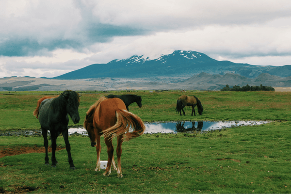
Hekla is Iceland’s most culturally resonant volcano, and for most of European history, its most feared. Located in south Iceland, approximately two hours from Reykjavik, Hekla has erupted more than 20 times since the settlement of Iceland in the 9th century, making it one of the most consistently active volcanoes in the country. The long shape with low ridge, roughly 40 kilometres in length, that resembles an overturned boat hull, belies a geological violence that has repeatedly altered the landscape for hundreds of kilometres in every direction.
The volcano’s first recorded eruption, in 1104, was a catastrophic VEI-5 event that buried farms across a wide area of southern Iceland and scattered ash across half the country. In medieval Europe, Hekla became synonymous with the underworld. European clergy described it as the Gateway to Hell, citing its regular and devastating eruptions as evidence that the entrance to the netherworld lay within its crater. It was widely believed that condemned souls passed through Hekla on their journey to damnation and that witches gathered at its summit on Easter nights to meet the devil. The dark cloak of clouds that often shrouds Hekla’s peak added to this mythology. The Icelandic word hekla itself means “hooded cloak” or “short hooded cloak,” a reference to the persistent mist around its top.
In practice, Hekla is a volcano of considerable danger and unpredictability. Its eruptions can begin with as little as 30 to 80 minutes’ warning, and its tephra is high in fluorine – a substance that can poison livestock and vegetation across enormous areas. The 1783 Laki eruption, which killed 79% of Iceland’s sheep stock, was partly attributable to fluorosis. Hekla has not erupted since 2000, and volcanologists have noted that the longer the interval between eruptions, the larger and more explosive the next event tends to be. Pressure measurements within the magma chamber have been considered elevated for some time. Hekla is closely monitored by the Icelandic Meteorological Office.
The landscape surrounding Hekla is one of Iceland’s most dramatic. Imagine black lava fields stretching to the horizon, created by successive eruptions across the past millennium. Guided day tours from Reykjavik reach the base of the volcano, and in calm conditions, experienced guides lead hikes toward the summit ridge.
Credit: Saira
Eyjafjallajökull – the World’s Most Mispronounced Volcano
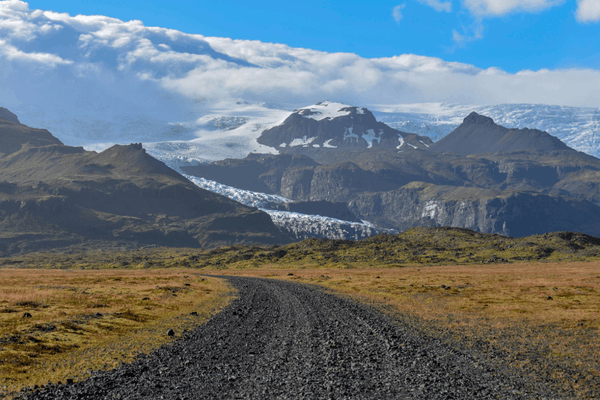
Before 2010, Eyjafjallajökull was known primarily to volcanologists. After April 14th of that year, it became one of the most discussed and consistently mispronounced words in the English language. The eruption began with a fissure opening on the mountain’s flank, producing lava flows that were initially accessible to visitors. The second phase, beginning on April 14th, was dramatically different: an explosive subglacial eruption that sent a column of ash and ice crystals 9 kilometres into the atmosphere and, carried by prevailing winds across Europe, grounded more than 100,000 flights and stranded millions of passengers for weeks.
Eyjafjallajökull (roughly pronounced “AY-yah-fyat-lah-YOH-kuhl”) is a stratovolcano covered by the Eyjafjallajökull glacier, from which it takes its name. Stratovolcanoes are built from successive layers of hardened lava and ash, creating the classic steep-sided cone shape, and they tend toward more explosive eruptions than the gentler shield volcanoes. The 2010 eruption was the largest volcanic event in Iceland since the Katla eruption of 1918 and caused widespread disruption, not due to lava flows, which did not threaten populated areas, but entirely because of the ash cloud it generated.
The volcano is geologically connected to the Katla volcanic system to its east, and historical patterns suggest that eruptions of Eyjafjallajökull are sometimes followed by larger eruptions of Katla within a short timeframe. Katla last erupted in 1918. The proximity of these two volcanic systems makes the south-central highlands of Iceland one of the most intensely monitored volcanic regions on the island.
Visitors today can hike the Fimmvörðuháls trail between Skógar and Þórsmörk, which passes directly between Eyjafjallajökull and Mýrdalsjökull and through the lava fields created by the 2010 eruption, including the newly formed craters Magni and Móði. The views along this trail are among the most spectacular in Iceland, and the walk itself stands as a direct physical experience of volcanic geology in action.
Credit: Save For Later Photo
Katla – Iceland’s Most Dangerous Volcano
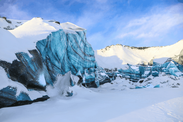
Katla is Iceland’s most feared active volcano, and for good reason. Hidden beneath the Mýrdalsjökull ice cap in south Iceland, Katla has erupted between 16 and 20 times in the past thousand years, typically at intervals of 40 to 80 years. The last major eruption was in 1918, which means that Katla has now been quiet for over a century, significantly longer than its historical average interval. Many volcanologists consider another eruption to be overdue.
What makes Katla particularly dangerous is not its eruptions alone but what follows them. Katla is a subglacial volcano, and when it erupts through the Mýrdalsjökull ice cap, the heat generated is sufficient to melt enormous volumes of glacier in a very short time. This produces a jökulhlaup (a catastrophic glacial flood) that can carry billions of cubic metres of water, ice, and volcanic debris down to the coast within hours. The 1918 eruption sent a jökulhlaup to the sea that was estimated to equal the combined flow of the Amazon and Nile rivers at peak discharge. The south coast of Iceland in this area has very few towns, partly because of the ever-present threat that Katla represents.
The Katla volcano and the area around Þórsmörk are accessible by guided super-jeep tours and on the multi-day Laugavegur and Fimmvörðuháls hiking trails. The landscape immediately around Katla is one of the most atmospherically powerful in Iceland – with its ash plains, river channels carved by past jökulhlaups, and the sense of a terrain that could transform completely without warning.
Credit: Hristina Eftimova
Grímsvötn – the Most Active Volcano in Iceland
Grímsvötn is not the most famous of the volcanoes in Iceland, but it is the most active. A subglacial basaltic volcano hidden completely beneath the northwestern side of the Vatnajökull ice cap, Grímsvötn has the highest eruption frequency of any volcanic system in the country. It was erupting at the same time as the catastrophic Laki fissure system in 1783, and it continued erupting until 1785. More recently, its 2011 eruption expelled a considerable quantity of basaltic tephra that cancelled more than 900 flights and sent ash clouds across Iceland, the UK, and parts of northern Europe.
Grímsvötn’s activity is fundamentally tied to the interaction between volcanic heat and glacial ice. Eruptions melt ice from below, which accumulates in the caldera as a subglacial lake. When the pressure becomes sufficient, the ice cap is lifted, and an enormous quantity of meltwater escapes suddenly as a jökulhlaup, flooding the coastal lowlands of southern Iceland. This cycle has been repeated dozens of times in recorded history, and continues today. The Grímsvötn volcanic system also shares its fissure structure with the Laki system, one of the most destructive eruption sources in the past thousand years.
Grímsvötn is not a visitor destination in the normal sense. It lies deep within Vatnajökull National Park, covered by hundreds of metres of ice. Its significance to Iceland’s volcanic story, however, is fundamental.
Credit: Karl Paul Baldacchino
Bárðarbunga – Iceland’s Largest Volcanic System
Bárðarbunga is a subglacial stratovolcano lying beneath Vatnajökull, Iceland’s largest glacier, and the heart of the country’s most extensive volcanic system. It’s a network approximately 200 kilometres long and 25 kilometres wide. Its caldera, which sits at around 2,000 metres above sea level beneath the ice, is one of the deepest subglacial calderas in Iceland, reaching 700 metres below the glacier’s surface.
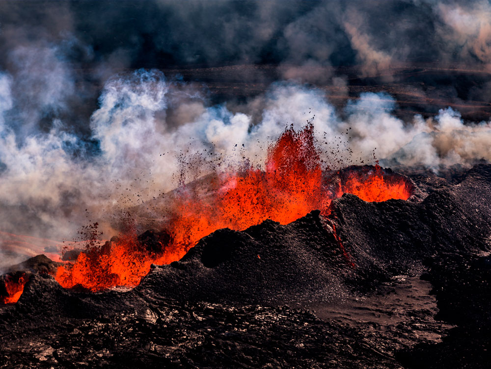
The Bárðarbunga volcanic system produced the Þjórsárhraun lava flow roughly 8,600 years ago. It’s the largest known effusive eruption in Iceland’s Holocene history, covering approximately 950 square kilometres. In historical times, its most dramatic eruption began on 29 August 2014, when a fissure opened in the Holuhraun lava field approximately 45 kilometres northeast of the caldera. The eruption produced the largest lava flow in Iceland since the Laki eruption of 1783, covering around 85 square kilometres before it concluded on 28 February 2015. It emitted enormous volumes of sulphur dioxide, significantly affecting air quality across Iceland, but produced little ash and had no impact on international flights.
The Holuhraun lava field is accessible on guided highland tours from Lake Mývatn and represents one of the most vivid opportunities in Iceland to stand on geological terrain that was created within living memory. The vast black expanse of fresh basalt stretching across the highland plateau is a striking reminder that Iceland’s landscape continues to be actively remade.
Credit: Lava Center
Laki – the Deadliest Eruption in Iceland’s History
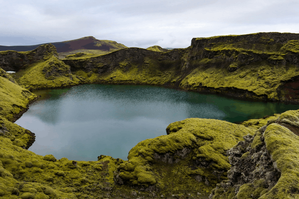
Laki is a fissure volcano, and it’s a crack in the Earth’s crust rather than a central cone. And part of the same volcanic system as Grímsvötn. Its eruption, which began in June 1783 and continued until February 1784, was one of the most consequential natural events of the past millennium. Over eight months, a series of fissures opened across a 27-kilometre row of craters known as Lakagígar, releasing approximately 14 cubic kilometres of lava and generating enormous quantities of sulphur dioxide and fluorine gases.
The immediate consequences in Iceland were catastrophic. Toxic gases poisoned livestock across the country. 79% of Iceland’s sheep were killed, along with over half its horses and cattle. Crops failed. Roughly 10,000 people and approximately a fifth of Iceland’s entire population died in the resulting famine, known in Icelandic history as the Móðuharðindin, or “mist hardships.”
The effects extended far beyond Iceland. The sulphur dioxide released by Laki created a toxic haze that spread across Europe, causing a dramatic drop in temperatures and crop failures from France to Russia. Tree ring records and ice core samples indicate that the eruption’s climatic effects were felt as far as North Africa and North America. Some historians have suggested that the resulting agricultural crisis in France contributed to the social conditions that led to the French Revolution of 1789. It’s a claim that remains debated but illustrates the scale of the eruption’s broader impact.
The Laki fissure system lies in the remote southern highlands of Iceland, accessible by guided super-jeep or 4WD vehicle in summer. The 115 craters of the Lakagígar system are visible along a hiking route through the Vatnajökull National Park and the surrounding lava field, which was entirely created in the 1783 eruption. It is one of the most geologically significant landscapes in Iceland.
Credit: Paul Taton
Askja – the Highland Caldera
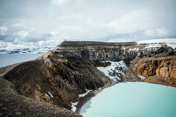
Deep in Iceland’s central highlands, Askja is one of the most remote and most extraordinary volcanic destinations in the country. A large caldera volcano in the North Volcanic Zone, Askja’s most significant historical eruption occurred in 1875, when the largest explosive event in Iceland since the settlement of the country in terms of tephra volume, sent ash across Scandinavia and into central Europe. The resulting air pollution and soil contamination devastated farming across large areas of northern Iceland and drove a significant wave of emigration to North America.
Inside the Askja caldera lies the Öskjuvatn lake, formed when the volcano’s last major eruption in 1875 caused the caldera floor to collapse. The lake is 220 metres deep and is the second deepest lake in Iceland. Adjacent to it is the Víti crater, a smaller explosion crater filled with geothermally heated water. It’s one of the few places in Iceland where visitors can swim in a volcanic crater lake, though the experience requires tolerance for strong sulphuric smells and very warm water.
NASA used the Askja region to train astronauts for Moon missions in the 1960s, a testament to its otherworldly, basaltic landscape. The area is accessible only in summer by guided highland tour or 4WD vehicle, and the journey through the Icelandic interior to reach it is itself one of the most desolate and spectacular drives in the country.
Credit: Ronan Furuta
Krafla – the Fires of the North
In the Lake Mývatn region of north Iceland, Krafla is a caldera volcano that has erupted 29 times in recorded history, making it one of the most active in the country. Between 1724 and 1729, a series of eruptions known as the Mývatn Fires caused widespread damage to farms and settlements in the area. More recently, a nine-year period of intense activity known as the Krafla Fires (1975–1984) produced a series of eruptions and lava flows that reshaped the landscape around Lake Mývatn and are still visible in the black lava fields that visitors traverse today.
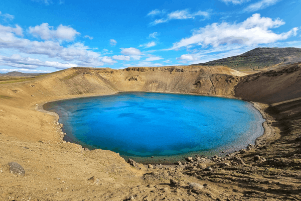
At Krafla, visitors can walk directly through lava fields created during the Krafla Fires – a sobering and exhilarating experience that makes the volcanic history of the area immediate and tangible. The Víti crater (whose name means “Hell” in Icelandic) is filled with brilliant emerald-blue water and sits at the edge of the steaming, geothermal landscape. The nearby Leirbotnavatn geothermal area is a constant reminder of the heat still present just below the surface.
Krafla is easily accessible from the village of Reykjahlíð on the shores of Lake Mývatn, making it one of the most convenient active volcanic landscapes to explore in the north of Iceland.
Credit: Pavol Svantner
Fagradalsfjall and the Reykjanes Peninsula
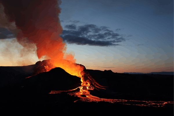
In March 2021, after approximately 800 years of dormancy, the Reykjanes Peninsula (the southwestern corner of Iceland where Keflavík International Airport is located) entered a new period of volcanic activity. The eruption at Fagradalsfjall began as a slow, effusive lava flow in the Geldingadalir valley, building new land rather than blasting ash skyward. Because it was both relatively safe and accessible, just 40 kilometres from Reykjavik, it quickly became one of the most visited eruption sites in Icelandic history, attracting hundreds of thousands of locals and tourists who hiked across lava fields to watch molten rock flow from the earth.
The 2021 eruption was followed by further eruptions in 2022 and 2023 at Fagradalsfjall and, from December 2023 onwards, at the Sundhnúkagígar crater row near the town of Grindavík. By 2025, twelve eruptions had occurred on the Reykjanes Peninsula in four years, marking a dramatic awakening after an 800-year period of geological quiet. Several eruptions forced temporary evacuations of Grindavík and the closure of the Blue Lagoon geothermal spa. As of early 2026, no eruption is ongoing, though monitoring continues closely and further eruptions on the peninsula are expected by geologists.
The Reykjanes Peninsula is now one of the most volcanically dynamic places accessible from any capital city in the world. Lava fields created by the recent eruptions are open to visitors via marked trails, and guided tours operate regularly from Reykjavik to the eruption sites.
Credit: Toby Elliott
Surtsey – the Island That Was Born
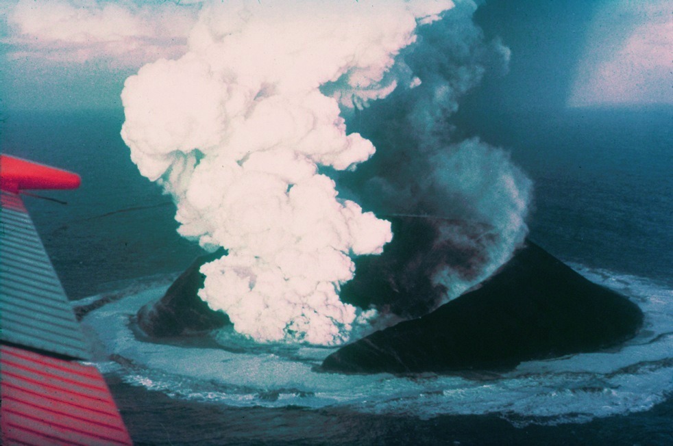
No account of the volcanoes in Iceland is complete without Surtsey. This is an island that did not exist before November 1963 and which rose from the sea through four years of submarine and subaerial eruptions off Iceland’s south coast. The eruption began on the ocean floor at a depth of 130 metres, and by November 15th of that year, the new island had broken the surface. At its largest, Surtsey covered 2.7 square kilometres.
What makes Surtsey remarkable beyond the drama of its formation is the scientific significance of what followed. Declared a nature reserve immediately after the eruption ended in 1967, Surtsey became the world’s most closely observed natural laboratory for the study of ecological colonisation and how life establishes itself on a completely sterile new landmass. Scientists have documented the arrival and establishment of every species, from the first moss and bacteria to seabirds that now breed there in considerable numbers. It was designated a UNESCO World Heritage Site in 2008.
Surtsey is not open to the public; access is restricted to authorised researchers to preserve the integrity of the ecological record. It can be viewed from the air on scenic flights from the Westman Islands.
Credit: Wikipedia
Visiting Iceland’s Volcanoes Safely
Iceland’s volcanoes are not static monuments; they are active systems that can change conditions rapidly. Several practical considerations apply to any visit.
Always check the current status before visiting. The Icelandic Meteorological Office and Safetravel Iceland provide real-time volcanic activity updates, road closures, and safety guidance. These should be consulted before any trip to volcanic areas, particularly on the Reykjanes Peninsula, near Hekla, or in the highlands.
Highland volcanoes require 4WD vehicles and summer access only. Askja, Laki, Holuhraun, and other highland destinations are only reachable in summer via designated F-roads (mountain roads), which require 4WD vehicles and close entirely from autumn to late spring. Attempting to drive F-roads without an appropriate vehicle is illegal and dangerous.
Guided tours provide safety and context. For most volcano visits, particularly Hekla, Askja, and the recent Reykjanes eruption sites, joining a guided tour with an experienced local operator provides both access to the best viewpoints and the benefit of someone who knows the terrain and the current conditions. Self-guided visits to active volcanic areas are possible but require careful preparation.
Volcanic gases are a genuine hazard. Sulphur dioxide and other volcanic gases can accumulate to dangerous concentrations near active vents, particularly in low-lying areas with poor wind circulation. Eruption sites may require or recommend gas masks. Warning signs should always be observed and respected.
Iceland’s volcanoes are accessible to all levels of visitors. From the easy roadside views of Krafla and Goðafoss adjacent volcanic terrain, to guided day hikes near Fagradalsfjall and Hekla, to multi-day highland expeditions to Askja and Laki, the volcanic landscape of Iceland rewards visitors of every fitness level and interest. The Perlan museum in Reykjavik offers an excellent introduction to Iceland’s volcanic geology for those who want to understand the landscape before venturing into it.
Conclusion
The volcanoes in Iceland are not a feature of the landscape but its foundation. Every black sand beach, every geothermal pool, every geyser, every hot spring and fumarole and lava cave is a product of the same forces that continue to push new material through the island’s crust, year after year, in a process that will not end in any human timescale.
To visit Iceland and not engage with its volcanic character is to miss the essential story of the place. Whether you stand at the edge of Askja’s caldera in the summer highlands, hike across lava hardened only a few years ago on the Reykjanes Peninsula, or simply understand that the hot water in your hotel room comes from the earth itself, the volcanoes in Iceland make themselves known. They always have.
To explore Iceland’s volcanic landscape and the extraordinary broader world it has created, discover our custom tours, crafted to take you further into the places that deserve it most.
FAQ
What is the famous volcano in Iceland?
One of the most famous volcanoes is Eyjafjallajökull, known for its 2010 eruption that disrupted air travel across Europe. Another well-known site is Fagradalsfjall, which has had recent eruptions.
Are volcanoes still erupting in Iceland?
Yes, Iceland is very geologically active, and eruptions still occur regularly. In recent years, volcanic activity has been frequent around the Reykjanes Peninsula, especially near Fagradalsfjall, showing that the country remains highly active.
Has lava reached the Blue Lagoon?
Lava has come close to the Blue Lagoon, especially during recent eruptions near Grindavík, but the spa itself has generally been protected. However, closures have happened temporarily due to safety concerns and nearby volcanic activity.
When did a volcano last erupt in Iceland?
The most recent eruptions have occurred in the Reykjanes Peninsula, including activity around Fagradalsfjall in 2023–2024. Iceland experiences eruptions fairly often due to its location on tectonic plate boundaries.