Iceland is built for hiking.
That is not a metaphor. The country’s geology – volcanic, glacial, and in constant flux – has produced a landscape of extraordinary variety across a remarkably compact area. Within a single day on the right trail, you can move from a geothermal valley of steaming vents and orange rhyolite mountains to a black obsidian ridge, a glacial river crossing, and a green valley nestled between two ice caps. No other country in Europe offers anything close to this range at this density.
Hiking in Iceland is also, in the right conditions, deeply accessible. Well-marked trails, a network of mountain huts, bus connections to the Highland trailheads in summer, and a culture of responsible outdoor life make the country welcoming to hikers of all experience levels, from families on a half-day walk to Reykjadalur’s thermal river to experienced trekkers completing the full Laugavegur trail.
This guide covers the essential hikes in Iceland and everything from multi-day epics to memorable day hikes, organised from the most accessible to the most remote.
Key Takeaways
- Hiking season in Iceland runs from late June to mid-September for Highland trails and F-road-dependent areas. Many day hikes near the Ring Road and South Coast are accessible year-round.
- The Laugavegur Trail – 55 kilometres from Landmannalaugar to Þórsmörk – is consistently named one of the most beautiful hikes in the world by National Geographic and is Iceland’s most celebrated multi-day trek.
- The Fimmvörðuháls Trail extends the Laugavegur by 25 kilometres across the pass between two glaciers, ending at Skógafoss waterfall on the South Coast.
- Hut bookings on the Laugavegur open months in advance and sell out quickly. Book via Ferðafélag Íslands (the Icelandic Touring Association).
- Highland hikes at Kerlingarfjöll, Landmannalaugar, and Askja require 4WD vehicles on F-roads and should not be attempted outside summer.
- Always register your hiking itinerary at Safetravel Iceland and check road and trail conditions at road.is before setting out.
Multi-Day Treks
The Laugavegur Trail
Distance: 55 km (Landmannalaugar to Þórsmörk)
Duration: 4 to 5 days
Difficulty: Moderate to challenging
Season:Late June to mid-September
The Laugavegur is the defining hike of Iceland.
Named the “hot springs route,” it has been listed by National Geographic among the twenty most beautiful trails in the world. That is a designation that, on the trail itself, feels entirely earned rather than promotional.
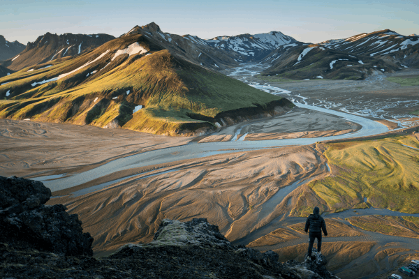
The route begins at Landmannalaugar, a geothermal reserve of extraordinary colour. The rhyolite mountains here are painted in shades of yellow, green, pink, red, and brown, streaked with sulphur-yellow snow and cut through by hot springs. The first day climbs through these mountains to the ridge of Hrafntinnusker, across fields of black obsidian that formed when volcanic lava cooled too quickly to crystallise.
Credit: Joshua Sortino
From there the trail descends through the sparse black ash plains of Mælifellssandur, a landscape so alien it has been used as an analogy for the surface of the moon. The later days take the hiker through the green river plains of Álftavatn and the volcanic black desert of Emstrur before the final descent into Þórsmörk (“The Valley of Thor”) which is a lush, birch-lined valley nestled between three glaciers.
The most popular direction is north to south, from Landmannalaugar to Þórsmörk, following a slight overall descent. River crossings are unavoidable. Some are unbridged, some require ankle-to-thigh-deep wading depending on conditions. Proper waterproof boots and hiking poles are essential, not optional.
Mountain huts are spaced approximately 12 to 16 kilometres apart along the route and book out months in advance for the peak summer weeks. Camping alongside the huts is an alternative if the huts are full.
Fimmvörðuháls Trail
Distance: 25 km (Þórsmörk to Skógar)
Duration: 1 to 2 days
Difficulty: Challenging
Season: Late June to mid-September
The Fimmvörðuháls is the natural extension of the Laugavegur, and for those who have completed the main trail, it is the logical next chapter.
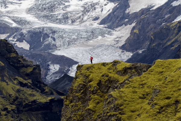
The route climbs from Þórsmörk over the high pass between Eyjafjallajökull and Mýrdalsjökull glaciers at 1,067 metres before descending towards the South Coast. Along the way it passes the Magni and Móði craters which were formed during the Eyjafjallajökull eruption of 2010, and then descends past more than twenty-five named waterfalls before reaching the iconic curtain of Skógafoss in Skógar.
Credit: Icelandia
Combined with the Laugavegur, the full route covers approximately 80 kilometres from Landmannalaugar to the coast. It’s one of the most satisfying long-distance hikes in Europe.
Many experienced hikers complete Fimmvörðuháls as a single very long day from Þórsmörk to Skógar. The ascent is steep and the pass can be icy and windswept even in July.
Day Hikes Near Reykjavík
Reykjadalur – The Thermal River Hike
Distance: 8 km return
Duration: 3 to 4 hours
Difficulty: Moderate
Season: Year-round, though the path can be icy in winter
Reykjadalur, or “Steam Valley”, is a day hike that ends with a bath.
The trail begins in Hveragerði, approximately 45 minutes from Reykjavík, and climbs steadily through a geothermally active valley. Steam rises from the ground on both sides of the path. Hot springs bubble from the earth alongside the trail. After roughly an hour of steady uphill walking, the valley opens into a wide, flat basin where a thermal river and its temperature naturally mixed between cool and hot water, runs through the grass, warm enough to swim in comfortably.

Credit: Iceland Highlights
Most visitors spend an hour or more in the river before the return walk. Bring a towel and a swimsuit; there are basic changing screens at the bathing area.
The hike itself is pleasant and well-marked. The first stretch is the steepest. The reward at the end makes every step worthwhile.
Glymur Waterfall
Distance: 7 to 8 km loop
Duration: 3 to 4 hours
Difficulty: Moderate to challenging
Season: June to September (river crossings make it impassable in winter)
Glymur is Iceland’s second-tallest waterfall, dropping 198 metres into a dramatic canyon above Hvalfjörður (Whale Fjord) approximately one hour’s drive from Reykjavík.
The hike to reach it is genuinely adventurous: you walk through a small cave at the base of the gorge, cross a river on a log bridge (from June onwards), and ascend a steep path aided by a fixed wire rope. At the top, the full height of the waterfall reveals itself from above, with views extending back over the fjord.

Credit: Save For Later Photo
Those comfortable continuing can cross the river above the falls and descend on the opposite bank, completing a proper loop. Those less confident on the steep, often wet terrain can return the way they came and still consider the hike entirely worthwhile.
Arriving early before 9am avoids the worst of the midday crowds. The car park can fill by late morning on summer weekends.
Þingvellir – Almannagjá Gorge
Distance: 3 to 8 km depending on route
Duration: 1 to 3 hours
Difficulty: Easy
Season: Year-round
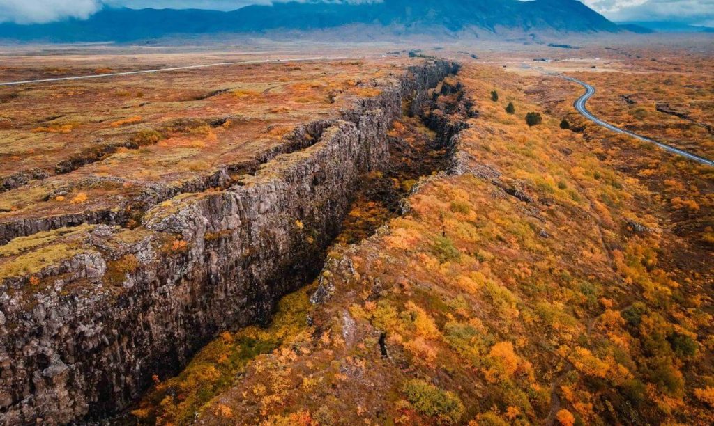
Þingvellir is Iceland’s most historically significant landscape and one of its most accessible walks.
The Almannagjá gorge cuts along the edge of the North American tectonic plate, and the path along its base is one of the most atmospheric and historically charged walks in Iceland. The gorge walls rise steeply on one side. The plain of the ancient Althing, which was the world’s first democratic parliament, established here in 930 AD, opens to the right.
Credit: Iceland Travel Guide
The walk is easy and paved in places, suitable for most visitors. The combination of geological drama and historical depth makes it an exceptional half-day from Reykjavík as part of a Golden Circle itinerary.
The Silfra fissure, which runs from the lake through the park, offers snorkelling and diving between the tectonic plates. It’s a different, entirely aquatic version of the same geological encounter.
Vatnajökull National Park
Svartifoss – The Black Waterfall
Distance: 5.5 km loop
Duration: 2 to 3 hours
Difficulty: Easy to moderate
Season: Year-round; may require crampons in winter
In the Skaftafell area of Vatnajökull National Park, the Svartifoss hike is one of the most rewarding short walks in Iceland.
The trail climbs through birch woodland before reaching the amphitheatre of black hexagonal basalt columns from which the waterfall takes its name. The 20-metre cascade framed by perfect geological geometry is one of Iceland’s most photographed sights, and it looks, in person, exactly as good as the photographs suggest.

Credit: K. K.
From the upper viewpoint, the trail continues to higher ground with panoramic views across the glacier and the coastal lowlands below.
The walk pairs naturally with a visit to the Skaftafell Visitor Centre, which provides detailed information about the national park and access to guided glacier hikes on the nearby Svínafellsjökull outlet glacier.
Dettifoss – Europe’s Most Powerful Waterfall
Distance: 1.5 to 3 km return from either bank
Duration: 1 to 2 hours
Difficulty: Easy
Season: Best accessed June to October (Route 862 from the west is paved; Route 864 from the east is gravel)
Dettifoss does not require a long hike.
It requires only that you walk close enough to feel the ground vibrate and let the noise of 193 cubic metres of water per second falling 44 metres into a grey basalt gorge do its work on you.

Credit: Richard Dorran
Europe’s most powerful waterfall by volume, Dettifoss is simultaneously the most overwhelming and the most accessible of Iceland’s great waterfalls. The path from the western car park to the viewing platform is short and relatively flat. The distance from the platform to the edge of the gorge is close enough to drench you in spray on a windless day.
From the same trailhead, a 30-minute walk north leads to Selfoss, which is a broader, shallower waterfall on the same river that offers a striking contrast in character.
Highland Hikes
Kerlingarfjöll – The Geothermal Highlands
Distance: Various (4 to 30+ km depending on route)
Duration: Half day to multiple days
Difficulty: Moderate to very challenging
Season: July to mid-September; 4WD required on F35 (Kjölur route)
Kerlingarfjöll is one of Iceland’s most visually extraordinary hiking areas and one of its most undervisited.
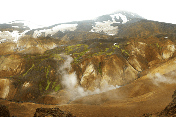
Hidden deep in the central highlands, the mountain range contains Hveradalir – a geothermal wonderland of steaming vents, boiling mud pools, rust-orange rhyolite peaks, and thermal rivers winding through volcanic valleys. The landscape looks, without exaggeration, like the surface of another planet.
Credit: Alexander Sinn
The accessible route from the Kerlingarfjöll mountain resort to the Hveradalir geothermal area is the most popular introduction to the area. The combination of striking colours of orange, red, and black against the snow, and the movement of steam from the ground creates photographic conditions unlike anything else in Iceland.
More experienced hikers can tackle longer routes, including the trail to Snæköllur peak and the multi-day circuit of the entire range. Guided day hikes depart from the resort.
The Kerlingarfjöll mountain resort provides accommodation and basic services. Reaching it requires a 4WD vehicle capable of the F35 (Kjölur route) and the shorter F347 access road.
Landmannalaugar Day Hikes
Distance: Various (5 to 20+ km)
Duration: 2 hours to a full day
Difficulty: Moderate to challenging
Season: Late June to mid-September; 4WD required
Even visitors who are not attempting the full Laugavegur trail will find Landmannalaugar worth the effort of reaching.

Credit: Karsten Winegeart
The geothermal reserve at the start of the trail is extraordinary in its own right. The famous natural hot spring, where the Laugavegur trail begins, is a shallow pool of warm water surrounded by black lava, and soaking in it after a day of walking is an experience that most visitors rank among the highlights of Iceland.
Day hikes from Landmannalaugar include the circuit of a steaming, colour-streaked mountain Brennisteinsalda, and the loop to the Ljótipollur crater lake, whose vivid crimson interior contrasts with the blue water at its base. Both offer spectacular views of the surrounding rhyolite mountains and provide a full introduction to Landmannalaugar’s extraordinary landscape without the commitment of the multi-day trek.
Essential Gear and Safety for Hiking in Iceland
Weather is the defining variable.
Iceland’s weather can shift from sunshine to horizontal rain, fog, and wind within minutes. This is true even in July, even on the most popular trails, even on days that began perfectly. Layering is not optional. It is the fundamental principle of dressing for hiking in Iceland.
The essential layers: a moisture-wicking base, a mid-layer fleece or down jacket, and a fully waterproof and wind-resistant outer shell. Waterproof trousers are strongly recommended for any multi-day hike.
Footwear matters as much as anything.
Waterproof hiking boots with ankle support are the standard for all Iceland hikes. On multi-day Highland routes, heavier-duty boots with a stiff sole help on the rocky and obsidian terrain. Trail runners are used by experienced hikers on the Laugavegur but offer less protection on the river crossings.
River crossings require judgment.
Several major hiking trails in Iceland, including the Laugavegur, involve unbridged river crossings. River levels can rise dramatically after rainfall. Cross at the widest, shallowest point; face slightly upstream; use poles for balance; move slowly. Never cross alone if you can avoid it.
Always register your itinerary.
The Safetravel Iceland website allows hikers to register their plans and emergency contacts before heading into the Highland interior. Rescue teams use this information if something goes wrong. For multi-day hikes in remote areas, registration is a professional and responsible standard.
Conclusion
Hiking in Iceland is one of the most complete outdoor experiences in Europe, not because the trails are always easy or the weather reliably kind, but because the landscape through which they move is genuinely extraordinary.
The Laugavegur moves through terrain that has no parallel on the continent. The walk to Svartifoss through the birch forest of Skaftafell ends at a sight that has shaped Icelandic architecture. The Reykjadalur trail ends in a warm river. Even a short walk along the tectonic boundary of Almannagjá at Þingvellir carries the weight of eleven centuries of history underfoot.
Whether you have an afternoon or a week, hiking in Iceland will give you more than you were expecting.
To experience Iceland’s finest hiking landscapes, and the extraordinary terrain that surrounds them, as part of a private, curated journey through the country, explore our bespoke Iceland tours.
FAQ
What is the most famous hike in Iceland?
The Laugavegur Trail is Iceland’s most famous hike, spanning 55 kilometers from Landmannalaugar to Þórsmörk over 3-4 days. This trek showcases otherworldly landscapes including geothermal areas, rhyolite mountains, glacial valleys, and volcanic deserts. Other popular hikes include Fimmvörðuháls, Glymur waterfall trail, and various Skaftafell National Park routes offering stunning glacier views.
Is hiking good for bone density?
Yes, hiking improves bone density through weight-bearing exercise that stimulates bone formation and strengthens skeletal structure. The mechanical stress from carrying body weight uphill builds bones in hips, legs, and spine, reducing osteoporosis risk. Regular hiking combined with adequate calcium and vitamin D intake effectively slows age-related bone loss and maintains skeletal health.
Is hiking good in Iceland?
Yes, Iceland offers exceptional hiking with diverse volcanic landscapes, glaciers, waterfalls, and geothermal areas. Trails suit all levels from easy coastal walks to challenging multi-day treks like Laugavegur. Summer (June-September) provides optimal conditions with midnight sun and accessible highlands. Prepare for rapidly changing weather including wind, rain, and cold even during summer months.
Do you need permits to hike in Iceland?
Most Icelandic hiking trails don’t require permits. However, popular multi-day treks like Laugavegur Trail require advance hut or campsite bookings during summer (June-September), which controls visitor numbers. Hornstrandir Nature Reserve has designated camping areas. Day hikes at Glymur, Skaftafell, and Reykjadalur need no permits. Always respect marked trails and follow Leave No Trace principles.